Manchester’s Streetscape – 1870 (Part 2 of 2)
Editor's Note: This is part 2 of a 2 part article. Click HERE to read part 1.
In Part 1 of this article, we looked at the post-Civil War boom which led to rapid expansion of downtown Manchester, leading to the historic Italianate buildings we still have today. We also looked at the role of Jeremiah D. Corey, and his influence in the creation of the new streetscape and appearance of our village between 1865 and 1875. We pick up here with a problem that developed from this rapid development.
The Need for a New Survey
The rapid growth and influx of new residents and businesses revealed a weakness in knowing exactly where property corners existed in the downtown area’s narrow lots. In 1833, village founder John Gilbert commissioned the original survey and plat for the future village, which was prepared by Hiram Burnham. The Manchester Mill fire of May 1853 destroyed a large segment of the original wooden structures on the north side of Main Street between the mill and Clinton Street, up to where the Manchester Hotel was located. This destruction, clean-up and partial rebuild between 1853 and 1865 obscured the locations of original survey irons.
As the period of rapid growth began, combined with escalating land prices, arguments broke out as to where the downtown lot corners exactly lie. It was clear to Jeremiah Corey and other civic leaders that a complete new survey would be needed, to precisely fix the individual lot corners and to include additional plats that had been added to the village since 1833.
Under Corey’s guidance, the Village Council executed a surveying contract in 1869 with Professor C. DeVolson Wood of the University of Michigan’s Civil Engineering Department. Wood resurveyed the entire village limits and confirmed the location of property corners in the contested areas, primarily the original downtown blocks. Wood was paid $253.80 for his work per published Village Council accounts. As an example of what Wood’s survey led to, the Enterprise was reporting on property resolution disputes as late as September 1880 where: “Wm. Burtless’ building on Exchange Place, was over on Dr. Conklin’s lot a foot or more, and it had to be moved.”
In Figure 5 below, the Burtless and Conklin buildings are among the group on the right-hand side.
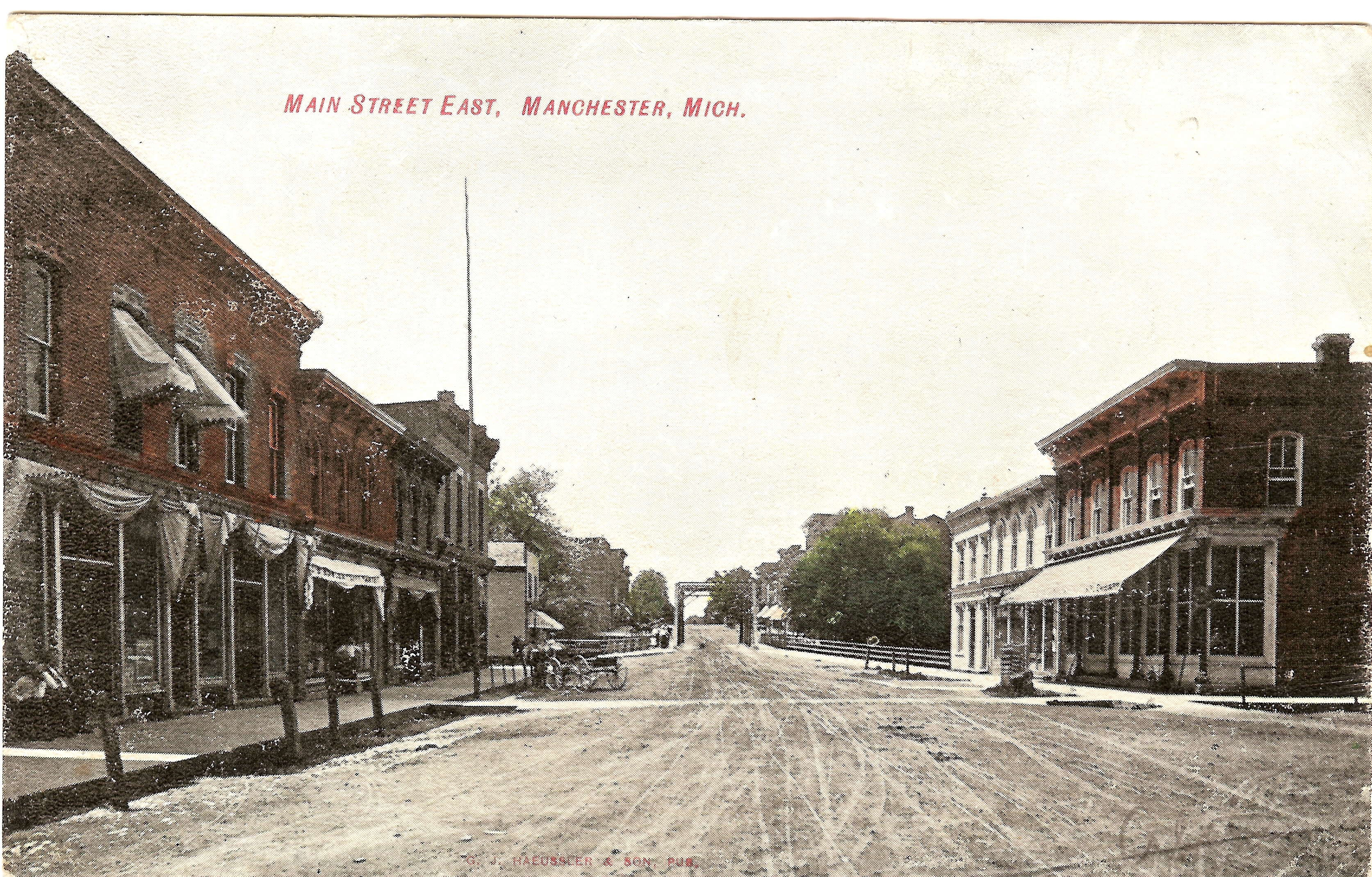
Figure 5 – The Burtless and Conklin Buildings on Near Right Side of Main Street
Figure 6 – A Bird’s Eye View of Downtown, 1872
DeVolson Wood was born at Smyrna, New York, in 1832. He graduated as a Civil Engineer from the Rensselaer Polytechnic Institute in 1857, and was Chicago-bound in search of a job when he ran out of money in Detroit. Penniless, he walked to Ann Arbor, where U of M President Henry asked him to substitute for an absent professor. Gifted and ambitious, Wood was soon given a permanent position. He became a celebrated teacher who designed the standard four-year engineering curriculum and oversaw the establishment of the first Department of Engineering. He remained at the University of Michigan until 1872, when he resigned to accept a similar chair in the Stevens Institute of Technology at Hoboken. He died in New York City on June 27, 1897, and was buried at Forest Hill, Ann Arbor.
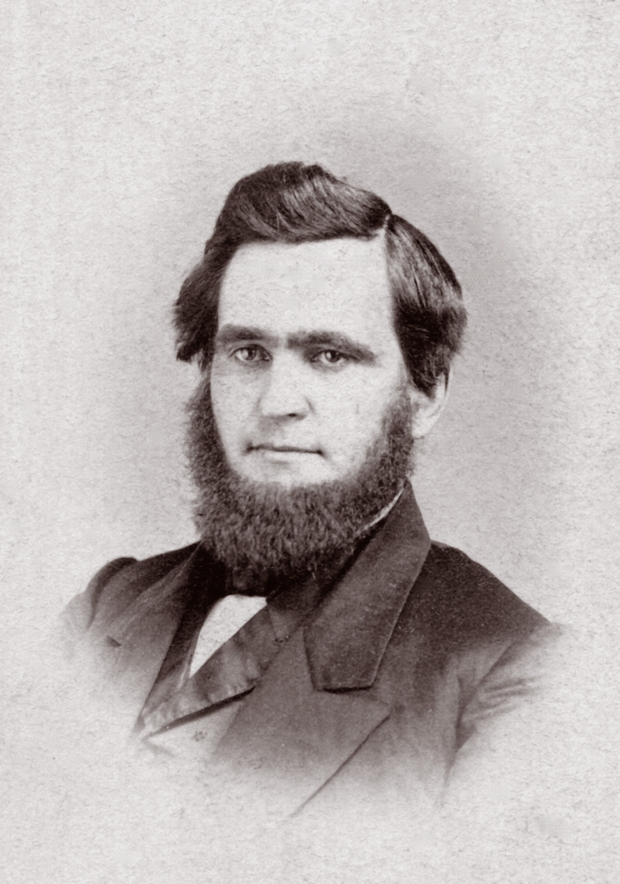
Figure 7 – C. DeVolson Wood
Wood was a prominent and respected surveyor, and Manchester Village officials saw his expertise as a way to resolve the growing property disputes. Wood was also affiliated with commercial firms which produced maps designed to promote certain towns and their businesses. Wood completed the original re-survey of Manchester in late 1869, and a copy of this map hangs in the current Village Council room. Wood’s work could also be used to develop promotional materials for the village, and it was the resulting 1870 promotional map of Manchester that was the real goal of Jeremiah Corey’s vision.
The 1870 Taylor & Bird Map
As noted earlier, by 1870 development both downtown and on Ann Arbor Hill was rapid. Both Mat Blosser and Jeremiah Corey were pushing for Manchester to continually promote itself as “the place” for people to live and businesses to locate, with the goal of making Manchester the number two town in Washtenaw County (it was number three at that point). One way a growing town could promote itself was by means of glossy, colorful and detailed maps and “birds-eye views”. While these views focused on commercial accomplishments, they also pointed to the harmony, civic pride and physical beauty inherent in the developing town. The first published work of this type detailing Manchester’s achievements was in the form of an 1870 large, colorful and highly detailed map. The finished product illustrates, to exact scale, all the buildings in town, and listed those residential and business owners who paid a patron fee to offset the cost of producing the map. The map is reproduced as Figure 9 at the end of this article.
DeVolson Wood’s surveying work was used as a starting point, and it is likely that he had a financial interest in the product. The map was produced by Taylor & Bird of 505 Chestnut Street in Philadelphia, and engraved by H. J. Toudy & Co. of the same address in Philadelphia. Mat Blosser reported on the map’s development beginning September 1, 1870: “Messrs. Taylor & Bird of Philadelphia are in town canvassing for a Lithographic map of this village. It is their intention, provided they can procure one hundred subscribers to furnish a correct and beautiful map, and we sincerely hope our citizens will subscribe liberally. The additions and attraction to our plat have been added and with our new Railroad will present quite a busy look.” On September 22, 1870, Blosser continued: “OUR VILLAGE MAP – Messrs. Taylor & Bird have finished canvassing for subscriptions for our village map, and the work will be completed in a few weeks. The gentlemen have gone to Jackson to get up a map for that city, and anyone who may want one of our maps will do well to apply to them at once, or at this office, as but a few extra copies will be issued.” The work was completed quickly, as on October 27, 1870: “Messrs. Taylor & Bird are delivering the map of Manchester. It is a beauty and all who have seen it say so.”
Taylor and Bird’s first names were never stated by Blosser, nor provided on the map. It took some research to determine who these gentlemen were. It turns out that “Bird” was not from Philadelphia, but was Judson Slatford Bird, a young civil engineer and a University of Michigan Class of 1870 graduate. He was born and raised on a farm outside Ann Arbor, and was 23 years old when he was in Manchester doing the work. He was clearly a student of DeVolson Wood and likely secured this work through Wood’s involvement. He worked with Taylor for 9 months in 1870-71, then became the city engineer for Jackson, Michigan. He went on to a multi-career life of civil engineering, map production and surveying, before dying young of meningitis in 1882 while in Kansas on a project.
“Taylor” was Frank Hamilton Taylor, later of the firm Taylor & Smith of Philadelphia. He was born in Rochester, NY on April 21, 1846. After Civil War service, he moved to Philadelphia to take an internship in a Lithography firm, choosing the city for its strong publishing industry as well as artistic community. During this time he also worked for the Daily Graphic, "the Only Illustrated Daily Newspaper in the World" as a "special artist". Taylor was hired by H. J. Toudy Company as part of a region-wide effort to produce city maps and birds-eye views, and was connected through DeVolson Wood to Judson Bird, with whom he worked on producing maps in Michigan, including Manchester’s and Dexter’s among others. Taylor is well known for his sketchings and illustrative works of Philadelphia and other regions, and there are several Internet sites devoted to him.
The map was engraved by H. J. Toudy & Co. of Philadelphia, established by partners Henry J. Toudy and William Toudy at 503-505 Chestnut Street, which specialized in maps, atlases, and city view prints, operating from 1865-1878. Although the firm executed "very fine specimens of work in all departments of the art," atlases, maps, and city views dominate among the noted works of the company, particularly images depicting the 1876 Centennial Exposition.
The 1870 map lists Manchester merchants and other prominent citizens (those that paid for the listing), their locations, and their products and services. It provides a highly accurate rendering of the village, which would be repeated in an 1872 Manchester “birds-eye” view drawing, which purportedly was exhibited at a world’s fair. The Village now had some promotional tools to convince potential residents and manufacturers to come and stay.
1870 Streetscape Improvements and Issues
As Mat Blosser continually emphasized, land in this area was selling for about $40 an acre and real estate was changing hands swiftly in 1870. Houses ranged from $800 to $2,000. Rent for the smaller home was $2 or $3 a week. Houses were in great demand. He editorialized that the village should build cross walks so that "we will be enabled to cross without danger of having our heads kicked oft, or getting in the mud." Two wooden crosswalks are visible across the dirt and horse manure of Main Street in Figure 7, located exactly where they are today by Clinton and Adrian Streets. The plank sidewalks, cobblestone gutters, hitching posts and water troughs along Main Street are also visible. Merchants paid 25 cents per week to have the dirt streets sprinkled to lay the dust in dry weather. There are two sitting chairs under the front awning of the Southern Washtenaw Mills for customers and passers-by. The use of storefront awnings is prevalent. Notably absent from the 1870 streetscape downtown are any trees – the idea of planting trees where horses would tie up was a foreign concept then.
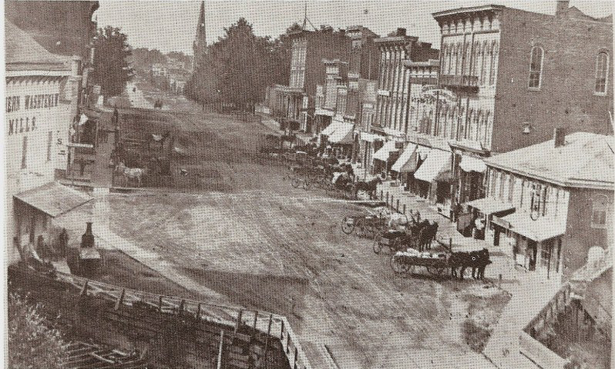
Figure 8 – View of 1870 Streetscape Improvements – Wooden Crosswalks
Sidewalks, and Hitching Posts
In the same year as DeVolson Wood’s map, the city fathers approved several downtown improvements, including on August 4, 1870: “Village Council passes resolution to construct sidewalks, extended time for Reynolds and Hewitt to construct sidewalk in front of Mill west of the bridge, and to draft an ordinance requiring a sidewalk on the north side of Jefferson east of the bridge in front of Dr. Conklin’s office.” The board walks also included one at the east side of the Union School for students.
The Village moved against careless property owners: On November 21, 1870, the Enterprise reported: “The street committee reported the walks from Wm. H. Bessac’s corner N. side of Exchange place to the west end of W. H. Stowell’s lot, also the walk commencing on the N.W. corner of J. J. Clarkson’s lot, running south of the line of the walk to corner of Washington & Boyn St., thence running westerly on west side of Boyne street to S. R. Spencers’ S. W. corner, unsafe. Mr. Palmer moved that the council instruct the Marshall to notify each owner or occupant on the line of said walks to remove the same within 10 days, and if not removed in said time, to remove the same forthwith. Carried.”
The Village Council also had problems with shop owners and residents not clearing the snow off walkways after a storm. An ordinance was passed in 1870 directing snow removal within certain time limits, or fines would be assessed. This problem still exists per Village Council proceedings. Fire protection alarms and suppression methods for downtown businesses also dominated the Council’s attention in 1870.
The Panic of 1873
The economic boom period described above came to an end in 1873. While national expansion of the railroad industry was aided by government land grants and subsidies, many of which were provided by individual villages and citizens as in Manchester’s case, speculators also played a prominent role. As the nation's largest employer outside of agriculture, railroads were able to attract investors with large sums of money to lend. This speculative cash infusion caused abnormal growth in the industry as well as overbuilding of railside docks and facilities. Eventually, overextended credit led to economic instability and calling in of notes beginning in 1873. This economic instability was further accelerated by national changes in monetary policy related to silver and its associated coinage, which led to a reduced money supply and increased interest rates.
The failure of a large national bank set off a chain reaction of bank failures, business bankruptcies, high unemployment, and a severe national depression. The panic affected all businesses in Manchester that needed to borrow money. On March 13, 1873, Mat Blosser commented on a worsening situation: “Don't think that because so many are desirous of selling out that business has ‘played out’ in this village. The truth is some of the would be sellers are played out." On March 20, 1873, the Enterprise further announced that the large Porter & Jaynes woolen mill had liabilities which totaled more than $15,000. This came as a shock to the entire community.
The immediate boom times were over, but Manchester would come back.
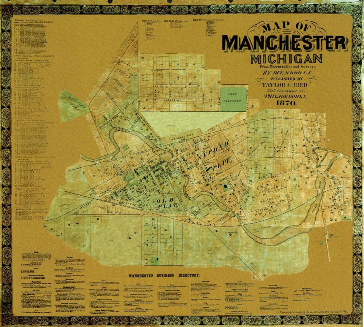
Figure 9 – Low-Resolution Image of 1870 Taylor & Bird Map of Manchester


You must be logged in to post a comment Login