Life on a Manchester Corner: a Complete History of the Intersection of M-52 and Main Street (Part One of Five)
By Ray Berg and Alan Dyer
Introduction
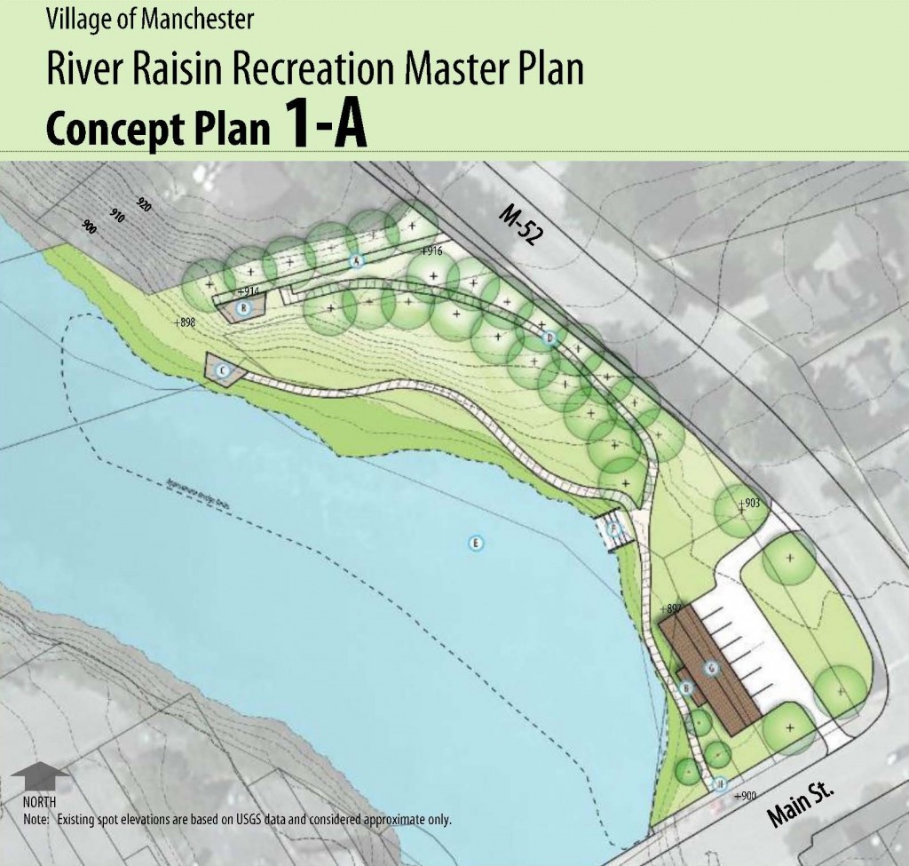
On February 6, 2014, the Village of Manchester hosted a public meeting seeking citizen input on the proposed River Raisin Recreation Master Plan, a long-term program to improve access to and recreational usage of the River Raisin within Manchester Village. Approximately 30 attendees viewed various options for improving the river frontage and the Manchester Mill Pond adjacent to Main Street, including the possibility of removing the dam and creating additional recreational land and opportunities. This near-term planning thus focuses on the northwest side of the “four corners” intersection of Main Street and M-52, which currently contains the “orange building” on the corner, an adjacent parking lot, and vacant land going up Ann Arbor Street (M-52). Citizen input and preferences were collected at the public meeting, and options will now be considered by Village Council for further actions.
This process follows up the October 14, 2010 purchase by the Village of Manchester of the property formerly known as 116 Ann Arbor Street, within this area of study, which included a dilapidated barn and home with adjacent Mill Pond frontage. This property was commonly referred to as the “Buss Property”, after a long-time former owner. The barn and home were demolished, and some limited grading done in preparation for future development. This now open site is viewed by hundreds of motorists and walkers every day as they approach Manchester’s downtown, and offers an excellent opportunity for park and recreational development, as well as a draw for visitors to come into our downtown.
Given this situation and the impending development of a recreational area, it seems timely to look back from a historical perspective as to what has existed on this “corner” of Manchester. This small parcel of land serves not only as a microcosm of Manchester’s business development since 1833, but also sheds light on the activities and motives of several of her leading citizens over the past 180 years. Our reporting will cover the land’s development from a natural state in 1833, through total development of the various land parcels by 1907, and then back to a nearly natural setting in 2014. We hope that it will prove to be both educational and entertaining.
Figure 1 – A Proposed Concept for the River Raisin Recreation Planning
The Scope of this Historical Study
Our study is focused on the corner piece of land bounded by the River Raisin Mill Pond on the west, Main Street on the south, Ann Arbor Street (M-52) on the east, and the former Lake Shore and Michigan Southern Railroad rail bed (which is also at the entrance to Chi-Bro Park) on the north. This area consists of four legal parcels of land within the southeast ¼ of Section 2 of Manchester Township:
PM-16-02-428-008 – Formerly designated as 116 Ann Arbor Street, consisting of entire Lots 4 and 5, and a part of Lots 3, 6, and 7, Block 1 of John W. Cowan’s First Addition, owned and utilized as one parcel. This is the former “Buss Place” property, which the Village purchased in 2010.
PM-16-02-428-009 – Designated as 230 East Main Street, consisting of a part of Lots 1, 2 and 3 of Block 1 of John W. Cowan’s First Addition, owned and operated as one commercial property. This is the commercial building previously housing Riverside Consign and Edward Jones Investments, and currently occupied in one office by Anesthesia Innovative Management. It is owned by Wei-Yi and Jing-Heng Ma of Laguna Woods, California.
PM-16-02-428-010 – Vacant commercial land west of 230 Main Street, consisting of a part of Lot 1, John W. Cowan’s First Addition, currently used as a reserved parking lot for the 230 East Main Street businesses, also owned by Mr. and Mrs. Ma.
PM-16-02-428-011 – Vacant commercial land west of 230 Main Street, referenced from a starting point in Lot 1, John W. Cowan’s First Addition, currently the east side property abutting to and including a portion of the mill pond, also owned by Mr. and Mrs. Ma.
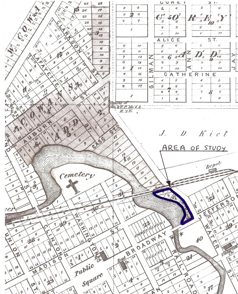
The land under study is illustrated in Figure 2, excerpted from the 1874 Plat Map of Manchester. The figure also shows the extent of the First Addition to Manchester developed by John W. Cowan, an influential developer in early Manchester.
Figure 2 – The Parcel of Land Being Researched, Highlighted as “Area of Study”,
Excerpted from the 1874 Plat Map of Manchester
The Beginning
The first owner of the corner under study was John Gilbert, founder of Manchester Village, who acquired the property from the U. S. Government in 1831. The original 1833 plat map of Manchester, prepared by Hiram Burnham for Gilbert, does not show our area of study as a road intersection. However, the map does indicate that a barn is situated somewhere within this land parcel near the mill dam, presumably for the use of Gilbert and the mill operators in the early years. There is no independent confirmation of this structure’s exact location. Manchester’s first burial also took place within this land in 1833, when Henry Annibil, a miller, died and was buried in a wooded area up Ann Arbor Street on the west side. He was subsequently reburied in Manchester’s “Old Burying Ground” in 1837.
On November 23, 1835, Gilbert sold all of his mill and land holdings to Stephen Fargo for $ 8,000. By September 1837, Fargo had sold shares of his holdings to his brother James H. Fargo, and Shepherd and Catherine Knapp of New York City. The Fargo brothers operated the mill and the Fargo & Fargo General Store. Stephen and James Fargo’s second village plat (1837) expanded the village eastward along what is now Main Street across M-52, but again the narrow strip of land along the east side of the mill pond up Ann Arbor Street was not platted.
The 1837 plat provides the first reference to a “Road to Ann Arbor” and the current alignment of the “four corners”. Douglass Houghton’s 1839 Washtenaw County survey map shows the further development of the “Ann Arbor” road heading north out of Manchester, and Samuel Pettibone’s 1843 Washtenaw County map shows a network of roads around Manchester which is immediately recognizable to modern residents.
Records of development during the 1840s of the property along the north side of Main Street east of the mill pond, or along the west side of Ann Arbor Street, are sketchy. Most likely there was little development due to unfavorable economic times and the availability of more convenient and choice building lots within the platted village. On April 18, 1840, James and Eliza Fargo sold several parcels of village land to John Dey Kief for $ 2,500, which included the corner under study (Liber P/485). On October 31, 1854, Kief then sold the northwest corner of Jefferson Street (now Main Street) and Ann Arbor Street (Liber 39/676) to Dr. Amariah Conklin for $ 12. It measured “2 rods by 4 rods” (33 feet by 66 feet). The parcel included a building “now occupied by Cadwell & Austin as a meat market”. This is the first reference to a building specifically occupying that corner. The assumption is that John Kief constructed the building there between 1840 and 1854, although this may be the same “barn” building referenced on the 1833 plat map.
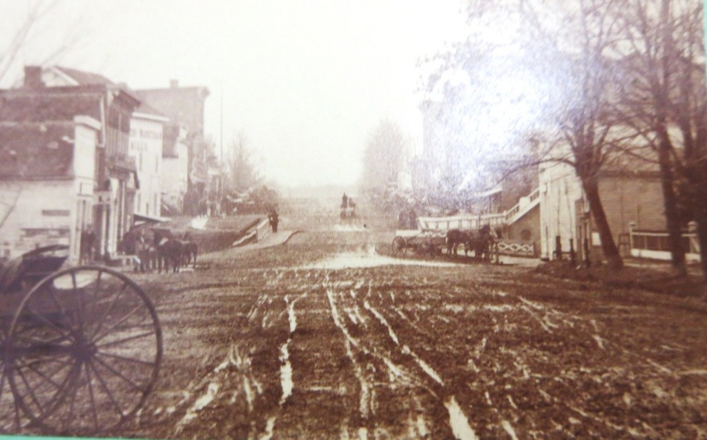
The only photograph which shows this building is portrayed in Figure 3. The “meat market” building is the white, gable-roofed structure on the right side of the photograph, with a horse and carriage in front of it. This photo dates from 1878, when it housed Dr. Conklin’s medical office, two years before the building’s teardown and rebuild.
The 1850 census lists an “Ambrose Cadwell”, age 17, a farmer living with Lucien Kief, John’s brother. The 1860 census has “Ambrose Cadwell” as a butcher living in Contra Costa, California (a surprising number of Manchester residents joined the gold rush to California). The identity of “Austin” has not yet been made. At this point in the research, the assumption is made that the meat market started in the early to mid 1850s at this corner.
Figure 3 – The original corner building on the right of picture, circa 1878. It first operated as the “Meat Market” and then as Dr. Amariah Conklin’s first medical office.
On February 26, 1856, Amariah and Lovina Conklin conveyed the north half of this parcel (2 rods by 2 rods) to “Elezer” (perhaps Ebenezer) M. Conklin for $ 300. It included the premises known as the “Meat Market in Manchester”, then occupied by Paul B. Minnis and Chauncey Walbridge (Liber 40/573). In the 1850 census, Chauncey Walbridge is an innkeeper in Manchester. In the 1860 census, his occupation is listed as “buying animals”. The only Paul Minnis that can be located in the 1850 and 1860 censuses is a shoemaker living in Ann Arbor. Their business connection in this building has not yet been determined. The 1856 plat map of Manchester shows only the presence of Dr. Amariah Conklin’s medical office on the north side of Exchange Place (Main St.), east of the mill pond. Two structures, one behind the other, are shown. No other structures or development are indicated in the parcel of study in this map. The 1864 plat map of Manchester also shows only Conklin’s office in this area.
The next major sale of John D. Kief’s land on this corner was to John W. Cowan on May 4, 1861. The parcel included approximately 50 acres, comprised of land in the southwest and southeast corners of Section 2, which was north of the River Raisin and west of Ann Arbor Street (Liber 48/301-02). This land ran along the west side of Ann Arbor Street and wrapped around the mill pond and river north of the existing village. Cowan subdivided this land and entered his plat on March 5, 1866. It showed Lot 1, the Main Street corner, as belonging to Conklin, and the remainder as undeveloped land.
From 1833 to 1861, development along Ann Arbor Street was minimal, limited to the meat market behind Dr. Conklin’s office, a possible business involving Minnis and Walbridge, and Dr. Conklin’s office fronting on Main Street. Both Cowan and Conklin contributed to future development on this corner, and a biographical sketch of each is provided.
Dr. Amariah Conklin
Dr. Amariah Conklin was born January 20, 1822 in Amenia, Dutchess Co., New York, the son of Dr. Ebenezer H. and Lucy Conklin. The senior Dr. Conklin moved his family to Sharon Township in 1832, where he practiced medicine and farming until his death in June, 1851. Amariah resided on the family homestead until the farm was divided in 1853, and then relocated to Manchester. He graduated from the Medical University of New York, and practiced medicine and surgery in Manchester where he “enjoyed an extensive patronage” from June 1849 until his death on May 25, 1892. He also served as Justice of the Peace and President of the village for a number of years, occupying that position until a short time prior to his death. Amariah was married to Lovina Carpenter in June 1853, and they had four children: Ebenezer, a physician; Amariah B., also a physician; Sophia, married to Ira Glover; and Julia, who became a teacher in the Manchester schools. Amariah moved back and forth between a farm residence in Sharon Township and a home in Manchester, while maintaining the office on the north side of Main Street. In 1872, he finally settled for good in the Village so that his children could benefit from the new high school built there.
Dr. Conklin established his practice in the front part of the “meat market” building purchased in October 1854. In 1880-1881, Dr. Conklin, perhaps in partnership with sons Amariah B. and Ebenezer, constructed the brick “Conklin Block” along the east side bank of the river and the north side of Main Street, for their medical practice and for other tenants.
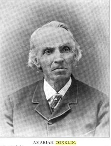
Figure 4 –Dr. Amariah Conklin – Early Business Owner in Cowan’s Addition
John W. Cowan
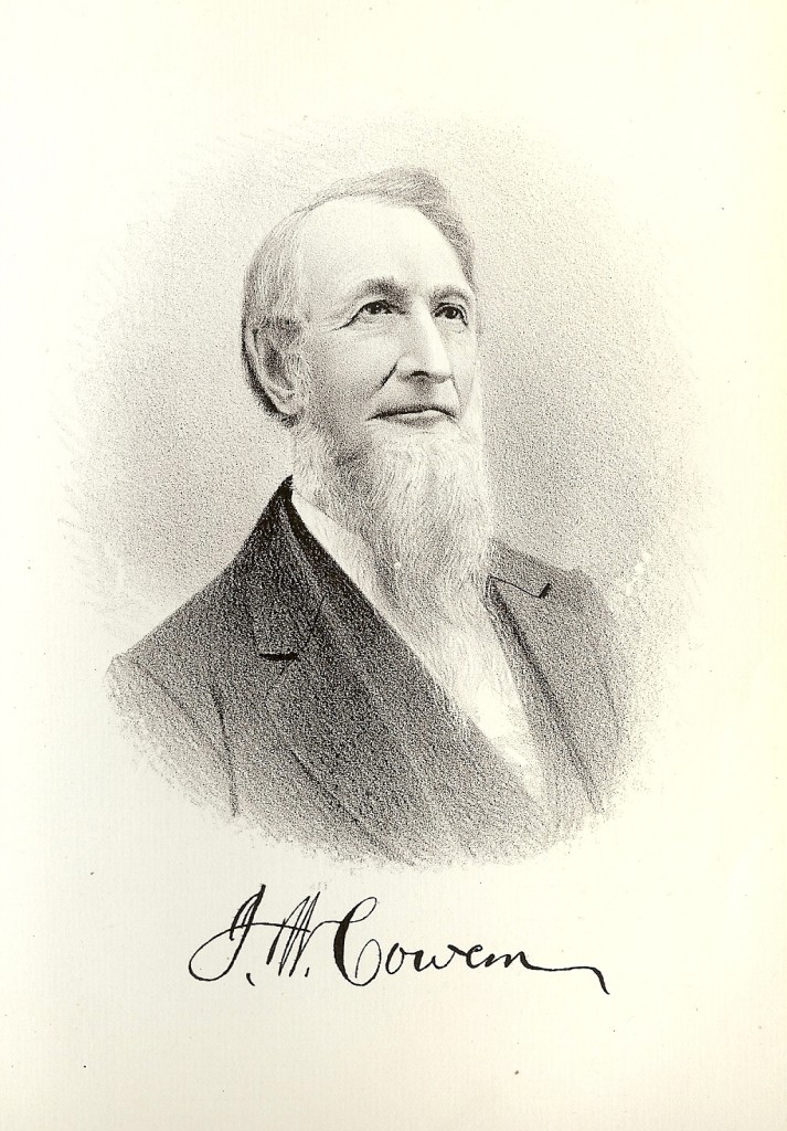
The major development of the area along Ann Arbor Street was the work of John W. Cowan, who began selling lots there after the Civil War in 1866. He was born on a farm in Washington County, New York, November 10, 1822, the son of John M. and Elizabeth (Greene) Cowan. They moved several times within the state, until the autumn of 1837, when John Sr., his second wife Hannah and the family emigrated to Michigan. They came by wagon along the Lake Erie shoreline, arriving in Manchester on January 20, 1838.
John W. Cowan began his career in Manchester as a laborer at $ 10 to $ 13 a month for Lewis Allen and Nicholas Becker, farmers in Sharon Township. When he accumulated sufficient money, he bought a team of horses and half-interest in a threshing-machine, often making as much as $ 5 a day for his labor. He was encouraged to increase his business, and spent a portion of the winters in teaming and dealing in dried fruit from Ohio, which he exchanged for lumber, shingles and furs, in the northwestern part of that state. During this period he began investing some of his surplus profits in real estate. In the mid-1840s he purchased a stock of bankrupt goods from Zachariah Chandler of Detroit, and in 1848 became owner of the Aaron Stockwell property in Manchester, consisting of a store and dwelling house. In 1851 he married Dorcas M. Thompson of Dexter and they had 1 child, Katie E., who died in 1862 of diphtheria. Two years following his marriage, the May 1853 Manchester Mill fire destroyed his short-lived business. He quickly recovered with profits from his existing farming interests, then in rapid succession engaged in carriage-making, meat-marketing, running a livery stable, making brick, auctioneering, building and contracting. Among his many business ventures was a wagon shop owned and operated with Henry Bierce on Duncan Street, east of Beaufort. He was a contemporary and likely business rival of John D. Kief. Both engaged in large land purchases and the platting of lands for expected residential growth after the Civil War.
Cowan prospered throughout the 1860s and early 1870s, the period of his most important real estate development activities. According to the 1870 census his real estate and personal property totaled $ 80,000, a substantial sum at that time. He also engaged in general farming and merchandising in Sharon Township on 1500 acres, until selling his property there in 1875, and moving to Manchester where he retired from all business in 1878. For many years he was also a Justice of the Peace and Notary Public. Cowan maintained a residence at the northwest corner of Duncan and Beaufort in 1870.
The Manchester Enterprise contains many references to John and Dorcas Cowan that throw additional light on their lives. John served as a vice-president of the 1871 4th of July celebration. On January 20, 1870, Mat Blosser of the Enterprise noted that Cowan “contemplates building a bridge across the river at the foot of Macomb Street in a few weeks” that would connect Cowan’s Second Addition (currently Riverbend Street) to the village. The project must have been delayed, for it was not until November 2, 1871 that the Enterprise reported “J. W. Cowan ‘is erecting’ a bridge across river. It connects his addition to the village from Cowan’s Avenue to Macomb Street.”. By April 17, 1873, it was still a work in progress: “…ice has drawn the piles, driven for a bridge across the river near the Mineral Springs, but we understand that Cowan intends to drive more and finish the bridge.” The bridge was eventually completed, but did not remain as a permanent structure within the village.
Horse racing and breeding were big favorites in Manchester in the early 1870s. On July 13, 1871, the Enterprise stated: “We are in need of a good half mile track—that will answer every purpose. We must have it too. The farmers and horse men are bound to have one, and when the farmers say they will, they will. Where the track will be made we cannot say just now, but will inform our readers at the earliest moment. The farmers have found it necessary to have a course in order to advance the interests of horse breeding. Who knows who has the fastest horse? Every man thinks he has, but he hasn’t. If we get a good track we shall soon know. Time will tell.”
On September 5, 1872 the Enterprise reiterated that horse breeders want a “horse park or race course.” Consequently, Cowan, being a horse fancier, offered to lease or sell a suitable piece of land north of the village to the interested parties. It possessed a stream and trees, and could be fixed up for a park and/or track at minimal expense. Those attending the meeting must have been in agreement, for they pledged $450 toward the project. But the times apparently did not allow it to happen, for the next week Blosser reported: “There are not a great many of our citizens that take much interest in the building of a riding park in this village, and those who do are so busy that they can’t attend to it just now. There will be another meeting at Goodyear’s office on Friday evening Sept. 13th.” There was no further mention of this meeting or apparently any other action taken.
Mrs. Cowan was very involved in the newly formed Women’s Foreign Missionary Society. According to the Enterprise, the Society stated: “…women are the centre of light and moral influence in the home and family”… (and) “the purpose of the society was “to create and cultivate a missionary spirit in the heart of the people, and to raise funds to send Christian women to the homes of China and India.” Mrs. Cowan also took a strong stand against drinking, serving as chairwoman of the Committee on Resolutions for the Women’s Temperance Alliance of Washtenaw Co. in 1875, and as its Vice-President in 1878.
Figure 5 – John W. Cowan, Prominent Manchester Developer
Like many other early Manchester residents, John Cowan suffered financial reverses in later life. He died October 25, 1895, at age 72, and Mat Blosser wrote in the Enterprise: “John W. Cowan . . . was for many years a prominent farmer in Sharon. He owned a large farm there besides considerable land in the village. In his palmy days he was liberal to a fault and no call for aid either public or private was made him without effect. He spent large sums of money in litigation and the justice and circuit court dockets were not complete without his name upon them. The general decline in price of farming lands and the gradual shrinkage of value which followed at the close of the war found him, like many other man [sic] unprepared to meet the financial crisis that followed. He moved to this village, but with his health impaired and a depleted purse he was not able to make more than a living. He had no children, but his wife a most estimable woman, survives him.”
During the Civil War, Manchester’s farmers and merchants experienced unparalleled prosperity as the price of grains, cattle and other commodities surged. Following the war’s end (1866-1873), the pent-up demand for new construction that prosperity had created expressed itself in the form of elegant Italianate brick homes and the downtown buildings which are still an essential part of Manchester’s charm. The coming of the second railroad in 1870 only added to the general feeling of optimism that had pervaded the village since peace had been declared. John W. Cowan, who had platted the land along Ann Arbor Street in 1866, was uniquely positioned to profit from this optimism and growth that would make Manchester a modern village.
(Editor's Note: Come back next week for the continuation of the article!)





You must be logged in to post a comment Login